The 16 priority trails for fixing trail gaps, connecting missing segments and building new trails in Colorado were announced by Colorado Governor John Hickenlooper last Wednesday.
The 16 priority trails were identified as part of the Colorado the Beautiful initiative. The initiative is intended to enable every person in Colorado to live within a 10-minute walk of an open space.
The Colorado Department of Natural Resources, Great Outdoors Colorado (GOCO), nonprofit organizations and state agencies collaborated to identify the 16 priority trails and elevated them to priority projects.
Many of the selected trails have been under development for several years and receive funding support from local support and partnerships. Some will require significant additional investment from the state, according to a press release from the governor’s office.
GOCO will invest $30 million in trails over the next four years, but no new state dollars are tied to the project. The first $10 million of funding is dedicated to the 16 priority trails and other qualifying projects.

1) Colorado Front Range Trail: The almost 900-mile-long Colorado Front Range Trail will run from Wyoming to New Mexico along the Front Range. It will connect historic points, parks and open spaces. Two-thirds of the trail remains to be completed, including three trail gaps on the Poudre River Trail. The gaps currently prevent a safe crossing from Fort Collins into Timanth, Windsor and Greeley. The envisioned 263-mile north section of the trail currently has 85 miles completed. Larimer county, CDOT and surrounding counties are working to secure funding for the I-25 Poudre River Bridge with a trail underpass.
2) Lower Valley Trail: The envisioned 47 miles of paved trail will begin in Glenwood Springs, travel through the Colorado River Valley and connect New Castle, Silt, Rifle and Parachute. It will end at the Mesa County line.
3) Rocky Mountain Greenway: The trail will connect the Rocky Mountain National Wildlife Refuge to Rocky Flats National Wildlife Refuge and Rocky Mountain National Park. The trail that will connect the Rocky Mountain Arsenal and Rocky Flats is nearly complete, according to a statement made by the Boulder County Board of Commissioners.

4) Colorado Riverfront Trail: The 33-mile trail will extend from Palisade through Grand Junction and Fruita and will end at the Kokopelli Trailhead outside of Loma. Ten miles remain to be constructed.
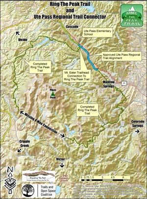
5) Ring the Peak: The 62-mile trail to circumnavigate Pikes Peak was envisioned in 1999, but two trail gaps in the loop remain.
6) Peaks to Plains Trail: The envisioned 65-mile trail corridor from the Continental Divide at Loveland Pass to the South Platt Greenway north of Denver has 10.5 mile of un-built trail remaining. An estimated 2.9 million people will use the trail every year.
7) High Line Canal: The 71-mile trail begins at the mouth of the Waterton Canyon in Douglas county and ends in Green Valley Ranch in Denver. The trail currently has six major trail interruptions, and 350,000 residents live within one mile of the canal.
8) Fremont Pass Trail: The 21-mile trail will connect Summit and Lake Counties. It will parallel Highway 91 over Fremont Pass, and connect at Copper Mountain with the Mineral Belt Trail in Leadville.
9) Alpine Loop Backcountry Byway: The 64-mile byway that connects Silverton and Ouray has a 1.5-mile gap near Lake City that will be completed this year.
10) Crested Butte to Carbondale Trail: The 74-mile trail serves Carbondale, Redstone and Crested Butte, but the 17-mile Crystal Valley segment to link Redstone and McClure Pass is yet to be completed.
11) Eagle Valley Trail: The envisioned 63-mile paved trail will travel the Eagle River Valley from Dotsero to Minturn. It will connect the Gore Valley Trail through Vail and the Vail Pass bike path. Approximately 26 miles of the trail remain to be completed.
12) Palisade Plunge: The Palisade Plunge is a proposed single-track trail that would provide users access to Palisade, Mesa and Powderhorn Mountain Resort. An environmental impact analysis has not yet been completed in order to move the project forward.
13) Paths to Mesa Verde: The 16-mile trail would act as a safe transportation route along Highway 160. It will link Mancos, Mesa Verde National Park, Cortez High School, Southwest Colorado Community College, the Phil’s World Mountain Bike Trails System and the Montezuma County Fairgrounds. The preliminary design work will be completed in 2016.
14) North Elk Creek: The trail will connect Staunton State Park’s trail system to the Cub Creek Trail and Mt. Evan’s Wilderness in the Pike National Forest. It will serve communities in Aspen Park, Conifer, Evergreen and Bailey. The environmental impact assessment is complete and the project will be completed in 2016 if it receives funding.
15) Eldo-Walker Trail Connection: The 1.5-mile trail will connect Eldorado Canyon State Park’s non-motorized trails to Boulder County’s Walker Ranch trail system.
16) Arkansas River Stage & Rail Trail: The conceptual 64-mile trail will connect Salida, Buena Vista and Leadville. An environmental impact analysis has not been completed, and funding will be required to continue planning the project.
Collegian Reporter Erin Douglas can be reached at news@collegian.com or via Twitter @erinmdouglas23.