The Student News Site of Colorado State University

The Rocky Mountain Collegian

The Student News Site of Colorado State University

The Rocky Mountain Collegian

The Student News Site of Colorado State University

The Rocky Mountain Collegian

Print Edition
Letter to the editor submissions
Have a strong opinion about something happening on campus or in Fort Collins? Want to respond to an article written on The Collegian? Write a Letter to the Editor by following the guidelines here.
Follow Us on Twitter
Crypto Exchange Listing: Types of Exchanges and Compliance Requirements
March 25, 2024

The crypto industry continues to evolve, fueled by the increasing institutional adoption of crypto. Today, numerous companies are entering the...

Flash flood warning issued, includes Fort Collins

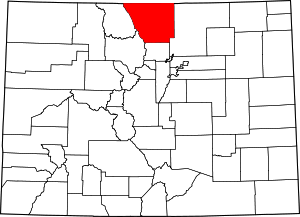
Map of the Fort Collins-Loveland Metropolitan ...
Map of the Fort Collins-Loveland Metropolitan Statistical Area (Photo credit: Wikipedia)

The National Weather Service released a flash flood warning for central Larimer county, which includes Fort Collins, until 4:45 p.m. Friday night.

The report warns of flooding and possible landslides in streams, creeks, culverts and roads within the High Park Fire burn area.

Ad

Flooding across highway 14 at mile marker 105 in Poudre Canyon near Stove Prairie,  has already been reported by the Sheriff’s department at 1:50 p.m., according to the statement.

For those within the area of possibly flooding, the report urges movement to higher ground as fast as possible.

See the report below.

See flooding, felled trees, or have questions? Text them to 970-430-5547 or news@collegian.com.

THE NATIONAL WEATHER SERVICE IN DENVER HAS ISSUED A

* FLASH FLOOD WARNING FOR…
CENTRAL LARIMER COUNTY IN NORTH CENTRAL COLORADO…

* UNTIL 445 PM MDT

* AT 152 PM MDT…DOPPLER RADAR INDICATED THUNDERSTORMS PRODUCING
HEAVY RAIN ACROSS THE WARNED AREA. UP TO ONE INCH OF RAIN HAS
ALREADY FALLEN. FLASH FLOODING IS EXPECTED TO BEGIN SHORTLY.

* LARIMER SHERIFF REPORTED FLOODING ACROSS HIGHWAY 14 AT MILE
MARKER 105 AT 150 PM MDT.

Ad

* SOME LOCATIONS THAT WILL EXPERIENCE FLOODING INCLUDE…
MISHAWAKA AND BUCKHORN MOUNTAIN.

PRECAUTIONARY/PREPAREDNESS ACTIONS…

HEAVY RAINFALL WILL CAUSE FLASH FLOODING OF CREEKS…STREAMS…ROADS
AND CULVERTS IN THE HIGH PARK BURN AREA. SOME AREAS AFFECTED INCLUDE
RIST CANYON…BUCKHORN CREEK…REDSTONE CANYON…STOVE PRAIRIE…AND
GULCHES DRAINING INTO THE POUDRE CANYON ALONG HIGHWAY 14. ROCK
SLIDES OR DEBRIS FLOWS CAN ALSO BE EXPECTED ACROSS ROADS IN THE BURN
AREA.

MOVE TO HIGHER GROUND NOW. ACT QUICKLY TO PROTECT YOUR LIFE.

View Comments (10)
More to Discover

Comments (10)

When commenting on The Collegian’s website, please be respectful of others and their viewpoints. The Collegian reviews all comments and reserves the right to reject comments from the website. Comments including any of the following will not be accepted. 1. No language attacking a protected group, including slurs or other profane language directed at a person’s race, religion, gender, sexual orientation, social class, age, physical or mental disability, ethnicity or nationality. 2. No factually inaccurate information, including misleading statements or incorrect data. 3. No abusive language or harassment of Collegian writers, editors or other commenters. 4. No threatening language that includes but is not limited to language inciting violence against an individual or group of people. 5. No links.
All The Rocky Mountain Collegian Picks Reader Picks Sort: Newest

Your email address will not be published. Required fields are marked *